North Korea

North Korea
The always bombastic and unpredictable North Koreans go hysterical again. This time the country is prepared to "go to war" with South Korea because that country is playing loudspeakers directed at North Korean territory. A headline from a UK paper reads, "More than 50 North Korea submarines 'leave their bases' as war talks with South continue "

Saturday, January 25, 2014

Destroying Assad's chemical weapons a multinational effort

Four months ago in September, after the UN and western nations found Syrian President Assad had indeed used chemical weapons on his citizens and rebels, the leader agreed under pressure to destroy his arsenal of Sarin, Mustard gas and VX nerve gas. The agreement, a result of delicate and intense negotiations between the US and Russia, envisioned a series of steps to that end.

Click on image for full picture
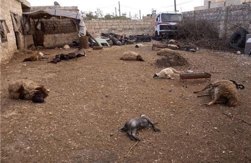
Despite initial sputtering angry denials by Assad's regime, UN and ultimately world leaders agreed that he had authorized and used nerve gas shells on concentrations of rebels intermixed with Syrian citizens. Animals are collateral damage ... photo from baomai.blogspot.com

Click on image for full picture
... as were babies and children. Photo from de.nachrichten.yahoo.com

As a CNN article at the time wrote, "initial inspections of declared chemical weapons sites must be completed by November; all production and mixing and filling equipment must be destroyed by November; and all chemical weapons material must be eliminated by mid-2014."

High stakes conversation between US Secretary of State, John Kerry (left), and Russian Foreign Minister Sergei Lavrov (right) over identifying, inventorying, removing, and destroying Syrian chemical weapons in an 11 month time frame, in the middle of a civil war. Photo from Pakistani Business Recorder - September 13, 2013

In fact, as the halfway point arrives, there has been substantive progress. In a USA Today article, it was estimated that Syrian leader Assad's military had about 1,000 metric tons of deadly chemicals and precursors, including nerve agents and mustard gas. "Most of the chemicals are precursors, which can be collected and then shipped out of the country, said Paul Walker, an analyst at Green Cross International, an environmental group based in Geneva."

By the end of October, Syria had submitted an inventory of weapons caches and volumes, and UN inspectors had confirmed the details at nearly all sites. At the same time, the Organisation for the Prohibition of Chemical Weapons (OPCW) - the UN authorized entity overseeing the implementation and adherence to the agreement - announced it was satisfied that the planned destruction of CW production, mixing and munition-filling capability had also been met.

UN authorized inspectors in the fall of 2013 ready to dismantle some mixing equipment in Syrian chemical weapons depots. Photo from Washington Post

The tricky part remains

Assuming all has gone as reported, that now leaves the 1200 tons (updated estimate by on-the-ground inspectors) of chemicals in various states of toxicity to be removed from the country, and then destroyed. On November 15 the OPCW approved a plan to transport Syria's chemical weapons to a location outside its territory by February 5, 2014, where the weapons would then be destroyed.

Russia has offered armored vehicles to transport the material to Syrian ports. By the end of December, according to http://groundreport.com "Russia has delivered 75 up armored trucks to Syria, along with other equipment that will be used to transport Syrian chemical weapons arsenal to sites for systematic destruction, Defense Minister Sergey Shoigu reported. “Over the three days from December 18-20 we have airlifted to the Latakia airport 75 vehicles, including 50 Kamaz trucks and 25 Ural armored trucks,” in 38 flights.

Click on image for full picture
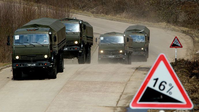
Russian vehicles such as these will move chemicals from Syria proper to the port city of Latakia.

Norway and Denmark have agreed to transport the chemicals from Lakatia, Syria to Italy where most will be handed over to the United States, some to the UK, and less dangerous chemicals to unnamed chemical companies.

Danish frigates to be used to transport Syrian chemicals. Photo from www.giornalisticalabria.it

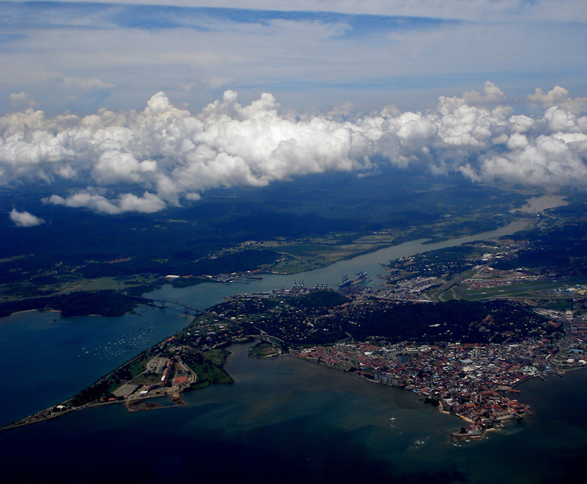
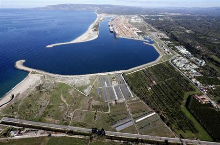
Italian port of Gioia Tauro (in the southern Italian region of Calabria) handles "dangerous" shipments of chemicals routinely, though this specific exercise caused a fair amount of concern across the country. Photo by REUTERS/Alessandro Bianchi/Files

The US will destroy the highest priority chemicals in a specially outfitted ship, the Cape Ray, while priority number 2 chemicals will be destroyed in the UK after transport there by the Royal Navy.

The Cape Ray left the Portsmouth New Hampshire shipyard in early January after being set up to destroy the most dangerous chemicals at sea (in international waters in the Mediterranean).

While it is easy to write a few sentences explaining the procedure - these pictures remind Teatree that the implementation involves real people, real equipment, lots of planning, lots of security. It appears the timetable has slipped a bit, but we shall see. Ironic that Russia will be hosting the Olympics in Sochi with heavy security to thwart terror threats, while transporting chemical weapons out of an allied country it robustly supports.

Saturday, January 18, 2014

Far East Russia, along the "road of bones"

Confession. This post is a result of Teatree watching, Long Way Round, a film documentary of two British actors riding motorcycles around the world, more or less, from London headed east across Europe, Kazakhstan, Mongolia, to Far East Russia, jumping to Alaska, Canada, mainland US to New York City. Along the way, in Far East Russia, they toiled over what is known, infamously, as the "road of bones."

Click on image for full picture
A different look at the country Russia, divided into regions by this birding website with the following description, "There are a bewildering array of regions, districts, autonomous regions, city districts and opther political subdivisions in Russia. Rather than dedicate a birding page to each we have chosen to split the huge landmass into several super-regions which have similar climates, avifaunal habitats and so forth. Graphic from http://www.fatbirder.com/links_geo/europe/russia.html

Far East Russia is essentially wild and sparsely populated land. And in the country's recent dark past regarding internal oppression 1930s-1940s), the communist leader Joseph Stalin used Siberia and Far East Russia as a convenient place to send individuals (by the millions) who were a perceived threat to the communist ideology, though more precisely, his growing personal power.

Labor camps throughout this cold distant land - made famous in Aleksandr Solzhenitsyn's books "The Gulag Archipelago," and "One Day in the Life of Ivan Denisovich" - were both the source for probably mindless work projects as well as the sites representing the end of life for millions of unfortunate Russian and Soviet Empire citizens. The particular section of highway in the graphic below was denoted the "road of bones" due to the practice of burying workers who had died constructing the road, in the roadway itself.

Officially known as the Kolyma Highway - the section in red - it is also known as the "road of bones." From Wikipedia, "It was constructed in the Joseph Stalin era of the USSR by Dalstroy construction directorate. The first stretch was built by the inmates of the Sevvostlag labor camp in 1932. The construction continued (by inmates of gulag camps) until 1953. The road is treated as a memorial, because the bones of the people who died while constructing it were laid beneath or around the road. The land there is permanently frozen so interment into the fabric of the road was deemed more practical than digging into the permafrost to bury the bodies of the dead."

Click on image for full picture
An icy bridge on the Road of Bones. Photo by CompassExpeditions.com.

Now in 2014, the highway remains dilapidated by modern standards, though in its defense, the land is so cold for much of the year, and so desolate, that ice roads can be built quickly and practically used for much of the year, without investing efforts and funds to build a paved roadway to modern standards.

Click on image for full picture
One of the colder places on earth - from Yakutzk to Magadan. Photo from askyakutia.com

Rather than build a major bridge to replace this relic, an ice road over the frozen river will suffice for nearly half the year, and for a couple months, six-wheel drive trucks can wade through the water except during the spring runoff. Photo from http://karakullake.blogspot.com

Hardy, or perhaps foolhardy, passenger vehicles link up with truck convoys during the brief season when the roads are not frozen ... Photo from the-bblue.blogspot.com

Click on image for full picture
The end point of this treacherous road from Yakutsk is the Russian town of Magadan, population just under 100,000. Photo from www.trekearth.com

Monuments

A haunting memorial was built along the highway nearing Magadan. It commemorates all those who died building the highway and the circumstances that led them to these ill fated labor camps.

Click on image for full picture
Despite some effort searching for the details of this monument (when, by whom, etc) not much has emerged. See figure at the bottom of the memorial to get a sense of size. Photo from http://caravanchronicles.com

An even more bewildering monument - at least in terms of "why" - is one in the town of Magadan itself. There are a few folks apparently still enamored with Stalin, just as there are those with Hitler. (Or those, for that matter, who deny the Holocaust ever occurred.)

A new statue of Stalin, erected in May 2013, was financed by the “Almazy Anabara” diamond-mining company and supported by its company’s president Matvei Evseev, who is a member of the United Russia party. Photo and article by Bolot Bochkarev, a journalist, fixer & guide based in Yakutsk, Russia His website is http://askyakutia.com/tag/road-of-bones/

Sunday, January 12, 2014

What's going on in Thailand?

"In this fight, defeat is defeat and victory is victory. There is no tie. There's no win-win. There's only win on one side," so said former Deputy Prime Minister Suthep Thaugsuban, one of the many anti-government leaders in Thailand who are not only opposed to the current government, but unhappy with the government announcement that new snap elections will be held February 2. According to a BBC article, demonstrators want to overthrow the current government before then.

What is going on?

Thailand, 67 million strong, is a country in Southeast Asia. Its capital, Bangkok is a major modern metropolis of over 10 million. Graphic from worldatlas.com

According to an article in the NY Times, "... the protest movement, a highly motivated, emotional and idealistic group largely led by the middle and upper classes in Bangkok and residents of southern Thailand, appeared to enjoy considerable support. Among those casting their lot with the protesters were the union representing Thai Airways, the national carrier; an association of rural doctors; the union representing employees of state-owned companies; and an association of university rectors.

Other institutions were as divided as the country itself. Many professors and students at one of Thailand’s most prestigious universities, Chulalongkorn, vowed to support the protest by blocking access to a central commercial district. But others at the university said they were outraged that the protest sympathizers would claim to represent Chulalongkorn.

The protesters are driven by hatred of Ms. Yingluck and her brother, Thaksin Shinawatra, a billionaire tycoon and former prime minister who is in self-exile overseas but wields great influence over the government. The protesters are passionately opposed to the family’s dominance in the country and believe that the elections will cement its hold on the political system. Disillusioned with electoral democracy, they want to replace Parliament with a “people’s council.”"

Click on image for full picture
Thailand is located on what used to be known as "Indochina" - the peninsula which contains Vietnam (88 million), Laos (6.6 million), Cambodia (nearly 15 million), Burma (nearly 53 million)and Malaysia (30 million). As the world knows, the Vietnam war in the 1950s through the mid seventies, devastated Vietnam, Laos, and Cambodia in various degrees. Graphic from http://www.pattayavillaholidays.com

Thailand is a country that has had a long troubled political history. The region had long battled the neighboring Burmese kingdom, losing to the Burmese in 1767 (close in time to the US revolution) only to regain a more unified Thai kingdom in the 1790s, and known as the Kingdom of Siam, was strong enough to be the only country on the peninsula to avoid European colonization, over the next 140 years. Thailand was able to negotiate with Japan in World War II, avoiding that conflict by and large. Since then, the nation has vacillated fleetingly between a monarchy, a republic, and a democracy, punctuated with many longer bouts of military dictatorship.

In spite the uneven governance, Thailand has developed a major tourist industry (7 percent of the economy), which due to the current unrest has stagnated, tipping the economy into a contraction.

Click on image for full picture
Thailand's military has built itself into a regional power, aided by its pro-western stance during the cold war. Military leaders have governed Thailand multiple times in the past 70 years. Photo from www.irrawaddy.org

Click on image for full picture
At the same time, Thailand has nurtured a tourist industry built on beautiful beaches especially along its long southern peninsula (and unfortunately, a rather vast underground sex trade, with the city of Pattaya notable, but not unique - see map). Photo of facility in Phuket from www.turkey-visit.com

All of this is background to the current unrest
Drearily, the latest flareup may be merely another phase in an uneven series of governance changes. The current prime minister,

Click on image for full picture
Ms. Yingluck, 46, shown here greeting US President Barack Obama, has been Prime Minister (appointed by the King), and interestingly has a Masters degree from Kentucky State University . Photo from www.dailymail.co.uk

Part of the current unrest lies in the fact that her brother Thaksin was formerly Thailand's Prime Minister, was overthrown in a military coup, and went into self-imposed exile after a court convicted him of abuse of power and corruption. The opposition maintains she remains in close touch with him, as does the Pheu Thai Party, which she heads. In other words, the same person who had been convicted and overthrown pulls strings or has undue influence behind the scenes.

Protestors have vowed to bring Bangkok to a standstill ... the military remains a looming presence ... a February 2 snap election which the government says will solve the issue, and protestors who as the opening sentence says is not the answer. Photo from www.straitstimes.com

Former Thai Prime Minister, Thaksin Shinawatra, is in exile in Dubai, but many protestors believe he runs the country through his younger sister. Photo from AP

Click on image for full picture
86year old King Bhumibol Adulyade is in poor health, but that does not prevent a sizable portion of the opposition from suggesting he take the reins of power directly for some period of time. The King is also the world's longest reigning monarch. Photo from www.washingtonpost.com

So, many faces, strains of unrest, new cycles of frustration, and a growing sense of crisis in Thailand's capital city.


Saturday, January 4, 2014

Panama Canal being expanded

We should not ignore what seems to be half the Middle East in religious and extremist flames: Syria, Lebanon, Turkey, Egypt, Libya, Iraq, and religiously-tainted ethnic tensions are tearing up the Central African Republic, and Bangladesh. But these conflicts just go on and on - we'll come back to them no doubt.

Instead, let's go to Panama, where the world famous Panama Canal is being expanded to handle larger ships. Progress?
Some might not be wholeheartedly in agreement to characterize the expansion as such that will allow ships carrying 12000 containers to pass through, instead of the current 5000 figure, but at least it isn't bombs and mayhem.

Panama is considered the southernmost country of Central America, and the connecting country between the two continents of North and South America. It has a population of a little over 3.6 million people, slightly more than Connecticut, and just a little less than Oregon. Graphic from wikitravel.org

Teatree admires the country's motto, "Pro Mundi Beneficio" translated "For the Benefit of the World," thinking that mottos of the nation might make for an interesting post.

A bit of history
Panama gained its independence from Spain in 1821, during a period of time when many South American countries emerged from the Spanish empire. From wikipedia, we read, "In the first eighty years following independence from Spain, Panama was a department of Colombia, since voluntarily becoming part of it at the end of 1821. The people of the isthmus made several attempts to secede and came close to success in 1831, and again during the Thousand Days' War of 1899–1902. When the Senate of Colombia rejected the Hay–HerrĂ¡n Treaty, the United States decided to support the Panamanian independence movement. In November 1903, Panama proclaimed its independence and concluded the Hay–Bunau-Varilla Treaty with the United States. The treaty granted rights to the United States "as if it were sovereign" in a zone roughly 10 miles (16 km) wide and 50 miles (80 km) long. In that zone, the U.S. would build a canal, then administer, fortify, and defend it "in perpetuity." In 1914, the United States completed the existing 83 km (52 mi) canal."

Click on image for full picture
The building of the canal is a story in itself, well documented and intriguing and costly in terms of human lives mainly from yellow fever. Photo from www.famous-places.com

So, as one can see, the United States appeared to have a hand in Panama's independence just after the turn of that century. Nearly 75 years later, when the U.S. was negotiating the transfer of the canal into the ownership and control of the Panama nation itself, California Senator S.I. Hayakawa stated, "We should keep the Panama Canal. After all, we stole it fair and square..." one of Teatree's all-time favorite quotes).

Click on image for full picture
Ship gliding along the waterway between locks. The route from ocean to ocean is 48 miles, with 9 locks raising ships over the terrain and back down again to sea level. Photo from www.panamacanadarealty.com

Click on image for full picture
Taking advantage of existing lakes and waterways wherever possible, the canal nevertheless still relies on rainfall to replenish the waters in the system, and indirectly is concerned with stable, forested watersheds. Note Rio Chagres river in the right of the graphic, feeding a reservoir which in turn stabilizes and feeds water into the canal system itself. Graphic from wikipedia

Click on image for full picture
Panama City, which anchors the Atlantic ocean canal-lock is remarkably urban and sophisticated. Photo from oceanocommunity.com

Strife

The new set of locks which can accommodate larger container ships is under construction, over budget, and therefore filled with intrigue, finger-pointing, and credibility on the line. It turns out that a large contractor from Spain is handling the construction, and by falling behind on timetable and money, the Spanish government has been drawn in to the fray.

Teatree is sure all will work out ... eventually. A BBC article sums up the story, "Construction is due to be completed in June 2015, nine months behind schedule. The overall cost of the project now expected to be $5.2bn.
Building work is now focused on the creation of a third set of locks to accommodate ships that can carry 12,000 containers. The largest ships currently able to navigate the Panama Canal carry 5,000. The Panama Canal handles 5% of the world's maritime trade."

The real bottleneck in the canal are the locks themselves. Ships are designed to fit the lock dimensions its seems ...

Click on image for full picture
Container ship passes through one of the nine locks with what seems to be inches to spare... photo from www.tiwy.com

Click on image for full picture
Nevertheless, we're going bigger. graphic from postgraphics.tumblr.com

Click on image for full picture
Teatree wonders how much more water will be used by the newer larger locks, and whether the landscape and rainfall will sustain it. He's sure the subject has been closely studied. The Rio Chagres river supplies 80% of the water in the canal as well as potable water to over a million people in Panama City, Colon, and San Miguelito, and is federally protected. Photo from wikipedia